Potential Impact Areas, Timeline, and Key Risks for Carriers During Tropical Storm Helene
Tia Amin
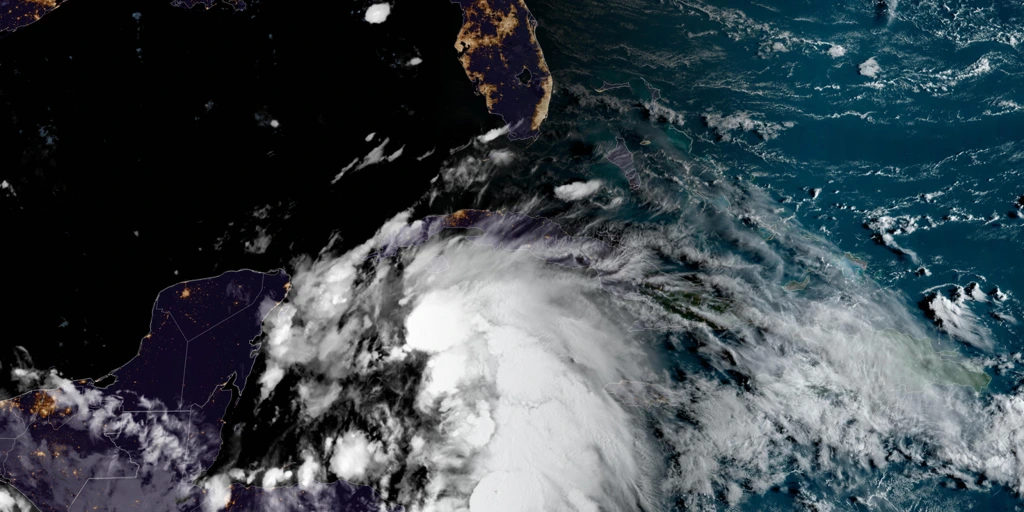
Table of Contents
At Stellar Logistix, the safety and well-being of our carriers, partners, and customers are our top priorities. With Tropical Storm Helene intensifying and forecasted to reach major hurricane status before making landfall on Florida’s Gulf Coast, we urge all carriers to take necessary precautions to protect themselves, their cargo, and equipment during this significant weather event.
Storm Overview: Tropical Storm Helene
Tropical Storm Helene is currently centered near Mexico’s Yucatan Peninsula and is expected to strengthen into a major hurricane by Thursday night as it approaches Florida. Dangerous conditions, including life-threatening storm surges, damaging winds, and heavy rainfall, are anticipated. The storm will bring strong impacts not only to Florida but also further inland across parts of the Southeastern U.S. over the coming days.
Potential Impact Areas
Helene is tracking towards Florida’s Gulf Coast and is projected to make landfall late Thursday night. However, impacts will be felt well ahead of that, with heavy rain bands and strong winds already reaching parts of Florida.
- Hurricane Warnings: Issued for the Florida Big Bend region and portions of southwest Georgia, including Tallahassee. Tropical storm warnings and watches are in effect across Florida, southern Georgia, and parts of South Carolina.
- Storm Surge Warnings: Florida’s Gulf Coast, from Indian Pass to Flamingo (including Tampa Bay and Charlotte Harbor), is under storm surge warnings. The highest surge levels are expected near the Big Bend and Apalachee Bay areas, with potential flooding that could exceed 10 feet above ground in some regions.
Carriers operating in these areas should plan ahead, follow local emergency management advice, and consider suspending operations in high-risk zones during this period.
Timeline of the Storm
- Wednesday: As Helene moves closer to the Yucatan Peninsula and Cozumel, it will bring high winds, storm surges, and heavy rainfall to the region. Some rain bands will already begin to affect parts of southern Florida and western Cuba.
- Thursday: Helene will likely reach peak intensity in the eastern Gulf of Mexico before making landfall Thursday night. Hurricane-force winds, intense rainfall, and storm surges will impact Florida’s Gulf Coast, particularly the Big Bend and eastern Panhandle regions. Severe weather conditions will be felt far from the storm’s center, with impacts extending well into Georgia and beyond.
- Friday: The storm will continue its inland movement, bringing high winds, heavy rain, and the potential for tornadoes across parts of Georgia, Alabama, the Carolinas, and the southern Appalachian regions. Strong gusts and flash flooding will be significant threats in these areas.
Key Risks for Carriers
- Storm Surge and Coastal Flooding: Carriers operating near coastal areas, especially along the Florida Gulf Coast, should be aware of serious flooding risks. Areas such as Cedar Key and the Tampa Bay metro area may experience significant surge levels.
- High Winds and Downed Trees: Hurricane-force winds are expected to extend well inland, bringing down trees and causing power outages. Ensure that your routes are clear of debris and hazards before resuming operations.
- Heavy Rain and Flooding: Forecasts predict 5 to 10 inches of rain across the Southeast, with isolated totals of up to 15 inches. This could lead to flash flooding, especially in mountainous areas like the southern Appalachians. Saturated ground may lead to uprooted trees, so carriers must stay alert for road closures and hazards.
- Tornado Threat: As with many landfalling hurricanes, Helene is likely to spawn tornadoes. This threat will be greatest across parts of Florida, southeastern Georgia, and the Carolinas. Be prepared for sudden changes in weather conditions, especially on Thursday and Friday.
Safety Recommendations for Carriers
- Monitor Weather Conditions: Keep updated with the latest advisories and forecasts. The Weather Channel and the National Hurricane Center offer real-time tracking to help carriers stay informed.
- Plan Your Routes Carefully: Avoid traveling through areas under hurricane or storm surge warnings if possible. Check for road closures or detours that may be implemented due to flooding or debris.
- Secure Cargo and Equipment: Take extra precautions to ensure all cargo and equipment are securely fastened to minimize damage in the event of high winds or flooding. Avoid parking vehicles in low-lying areas or near water.
- Communicate with Dispatchers: Stay in close contact with your dispatch team for the latest updates on the storm’s progression and road conditions. Ensure that all team members are aware of the risks and prepared to adjust their schedules if necessary.
Stay Safe and Informed
The weather conditions resulting from Hurricane Helene are expected to be severe and widespread, affecting not just Florida but many inland areas across the Southeast. Carriers should prioritize safety and delay operations in high-risk zones. As always, Stellar Logistix is committed to supporting you through these challenging times.
For real-time updates on weather conditions, please visit the National Hurricane Center or follow local weather services for regional advisories.
Thank you for your attention, and please take every precaution necessary to stay safe.